© 1997   A   B   S   O   L   U   T   E   L   Y       F   L   O   R   I   D   A       M   A   G   A   Z   I   N   E
<-- More Absolutely Florida
FloridaNature

Ecotourism


A beautiful, peaceful and adventurous way to see Florida's interior is by canoe. Florida's rivers range from 25 to 273 miles, fed by a vast network of underground streams, springs, and rainwater, and each are unique. Have an adventure on crystal clear rapids, paddle under a lush forest canopy, or glide through the mysterious Everglades teaming with fish, gators and birds of every variety. The Panhandle area holds the biggest selection of navigable rivers and streams.

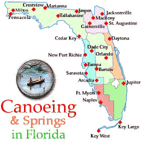
Either click the cities on the interactive map on the left, or select a location from the following list :
Crestview

Marianna

Dade City

Fort Myers

Naples

Jupiter

Orlando

New Port Richie

Daytona

Gainesville

Pensacola

St. Augustine

Jasper

Jacksonville

Bartow

Tallahassee

Tampa

Related stories:   State Parks   Adventure Tours [Coming Soon!]   Boat Rentals [Coming Soon!]

Panhandle
Pensacola Area
Canoeing
PERDIDO RIVER
27 miles. Start 3 miles W. of S.R. 97-A at end of Jackson Springs Road. This river borders the state of Alabama.

SWEETWATER/JUNIPER CREEKS
15 miles. Start 2 miles E. of Munson off S.R. 4. Water may rise quickly after a heavy rain.

Crestview Area
Canoeing
COLDWATER CREEK
16 miles. Start 15 miles E. of Jay on S.R. 4.

SHOAL RIVER
27 miles. Start on S.R. 285.

YELLOW RIVER
50 miles. Start on S.R. 2 in Oak Grove in northern Okaloosa County. Swift with many partially submerged logs, use caution

Jasper Area
Canoeing
SUWANNEE RIVER
141 miles. Start at bridge on S.R. 6. Scout dangerous shoals above White Springs.

WITHLACOOCHEE RIVER
32 miles. Start from bridge on S.R. 145

Tallahassee Area
Canoeing
AUCILLA RIVER
19 miles. Start 1 mile S. of Lamont on U.S. 19/27. Rapids and dams.

LOWER OCHLOCKONEE RIVER
67 miles. Start at the S.R. 20 bridge.

UPPER OCHLOCKONEE RIVER
58 miles. Start at the S.R. 12 bridge.

SOPCHOPPY RIVER
15 miles. Start on forest road 346, 5 miles N. of Sopchoppy. Water level fluctuates after heavy rains.

WACISSA RIVER
14 miles. Start 1 mile S. of Wacissa off S.R. 59.

WAKULLA RIVER
4 miles: Start is from S.R. 365.

Springs
ALAPAHA RISE
Wesllake, Florida (near Perry)

BLACK SPRINGS
Kynesville, Florida (near Springfield)

BLUE SPRING
Mayo, Florida (near Perry)

BLUE SPRING
Madison, Florida

GAINER SPRINGS
Bennett, Florida (20 miles N of Panama City)

GLEN JULIA SPRINGS
Mount Pleasant, Florida (6 miles NE of Quincy)

HOLTON SPRINGS
Adams, Florida

INDIAN SPRINGS
Greensboro, Florida

LIME SPRINGS
Ellaville, Florida

BONNET SPRINGS
Luraville, Florida (7 miles E of Madison)

PEACOCK SPRINGS
Luraville, Florida

PITTS SPRINGS
Bennett, Florida

PONCE DE LEON SPRINGS
Ponce de Leon, Florida

TELFORD SPRINGS
Luraville, Florida

WILLIFORD SPRINGS
Bennett, Florida

WACISSA SPRINGS GROUP
Wacissa, Florida

WAKULLA SPRINGS
Wakulla, Florida

Marianna Area
Canoeing
CHIPOLA RIVER
50 miles. Start at the Florida Caverns State Park or S.R. 167. Watch for exposed shoals just below S.R. 274.

ECONFINA CREEK
22 miles. Start at Scott's Bridge, 4 miles W. of U.S. 231.

HOLMES CREEK
20 miles. Start at wayside park in Vernon on S.R. 79.

Springs
BECKTON SPRINGS
Vernon, Florida, (near Holmes)

BLUE HOLE SPRING
Marianna , Florida (near Jacksonville)

CYPRESS SPRING
Vernon, Florida

SPRINGBOARD SPRINGS
Marianna, Florida

West Central
Tampa Area
Canoeing
ALAFIA RIVER
13 miles. Start at Alderman Ford County Park on S.R. 39.

LITTLE MANATEE RIVER
5 miles. Start on U.S. 301

UPPER MANATEE RIVERTOMOKA RIVER
16 miles. Start on S.R. 40, I mile W. of 1-95 at Ormond Beach. 5 mile loop.

Springs
CRYSTAL SPRINGS
Zephryrhills, Florida

CRYSTAL RIVER SPRINGS
Crystal River, Florida

HOMOSASSA SPRINGS
Homosassa Springs, Florida

CHASSAHOWITIZKA SPRINGS
Homossasa Springs, Florida

EUREKA SPRINGS
Tampa, Florida

HART SPRINGS
Wilcox, Florida

WARM SPRINGS
Venice, Florida

WEEKI WACHEE SPRINGS
Weeki Wachee, Florida

New Port Richie Area
Canoeing
PITHLACHASCOTEE RIVER
5 miles. Start from Rowan Road Bridge just N. of S.R. 518.

East Central
Daytona Area
Canoeing
BULOW CREEK
13 miles. Start at Bulow Ruins State Historic Site. 7 mile upstream loop.

SPRUCE CREEK
14 miles. Both start and finish are at Moody's Bridge, 1 mile S. of Port Orange interchange on 1-95, on road leading to Spruce Creek Airport.

Springs
ALEXANDER SPRINCS
Astor Park, Florida (Ocala National Forest, Ocala)

BLUE SPRING
Orange City, Florida

FERN HAMMOCK SPRINGS
Astor, Florida

JUNIPER SPRINGS
Astor, Florida

PONCE DE LEON SPRINGS
Barberville, Florida

WHITEWATER SPRINGS
Palatka, Florida

Southwest
Naples Area
Canoeing
BLACKWATER/ROYAL PALM HAMMOCK CREEK
13 mile loop: In Collier-Seminole State Park. Use caution in bad weather.

Fort Myers Area
Canoeing
HICKEY'S CREEK
4 miles. Start off Bateman Road, 2 miles S. of S.R. 80.

Central
Orlando Area
Canoeing
ECONLOCKHATCHEE RIVER
22 miles. Start on S.R. 419.

WEKIVA RIVER
25 miles. Start at Kelly County Park on S.R. 435 just N. of Wekiva Springs State Park.

Dade City Area
Canoeing
WITHLACOOCHEE RIVER (south)
84 miles. Start from Coulter Hammock Recreation Area in the Withlacoochee State Forest.

Bartow Area
Canoeing
PEACE RIVER
67 miles. Start in Fort Meade at City Park at U.S. 98 bridge.

Northeast
St. Augustine Area
Canoeing
PELLICER CREEK
4 miles. Start on U.S. 1.

Gainesville Area
Canoeing
SANTA FE RIVER
26 miles. Start 2 miles N. of High Springs on U.S. 41.

TOMOKA RIVER
16 miles. Start on S.R. 40, I mile W. of 1-95 at Ormond Beach. 5 mile loop.

MacClenny Area
ST. MARY'S RIVER
66 miles. Start from S.R. 121, 5 miles N. of Macclenny.

Springs
BRANFORD SPRING
Branford, Florida (near Chassahowitzka)

BLUE SPRING
Bronson, Florida (near Chassahowitzka)

BLUE SPRINGS
High Springs, Florida (15 miles NW of Gainesville)

FANNING SPRINGS
Fanning Springs, Florida (30 miles SW of Gainesville

FLETCHER SPRINGS
Hatchbend, Florida (8 miles S of Branford Springs)

GINNIE SPRINGS
High Springs, Florida

GURANTO SPRINGS
Rock Bluff Landing, Florida

ICHETCKNEE SPRINGS GROUP
Fort White, Florida

MANATEE SPRINGS
Chiefland, Florida

OTTER SPRINGS
Wilcox, FLorida

RAINBOW SPRINGS
Dunellon, Florida

ROCK BLUFF SPRINGS
Bell, Florida

SALT SPRINGS
Salt Springs, Florida

SUN SPRINGS
Wilcox, Florida

TURLE SPRINGS
Hatchbend, Florida

WELAKA SPRING
Welaka, Florida

Jacksonville Area
Springs
KINI SPRINGS
Bethel, Florida

LITHIA SPRINGS
Kithia, Florida

MORRISON SPRINGS
Redbay, Florida

NATURAL BRIDGE SPRINGS
Woodville, Florida

NEWPORT SPRINGS
Newport, Florida

RAINBOW SPRINGS
Dunellon, Florida

SILVER GLEN SPRINGS
Salt Springs, Florida

SILVER SPRINGS
Ocala, Florida

ST. MARKS SPRINGS
Woodville, FLorida

SUWANEE SPRINGS
Live Oak, Florida

TROY SPRING
Branford, Florida

VORTEX BLUE SPRING
Ponce de Leon, Florida

WALDO SPRINGS
Perry, Florida

Southeast
Jupiter Area
Canoeing
LOXAHATCHEE RIVER
8 miles. Start 5 miles W. of Jupiter, at end of dirt road which begins on E. side from toll booth of Florida Turnpike at S.R. 706 interchange, .

CANOE OUTFITTERS OF FLORIDA
9060 West Indiantown Road, Jupiter Florida
561/746-7053


<